
Serving tech enthusiasts for over 25 years.
TechSpot means tech analysis and advice you can trust.
In context: New research reveals that South Africa's land is rising not due to deep-earth forces but because of severe water loss from droughts and groundwater depletion. This discovery presents a powerful new approach to monitoring water scarcity and informing resource management in an era of growing climate uncertainty.
Over the past decade, parts of South Africa have risen by as much as six millimeters – a subtle but measurable shift detected by a network of high-precision Global Navigation Satellite System (GNSS) receivers. These instruments, which track millimeter-scale changes, revealed a pattern that overturns long-held geological assumptions: vanishing groundwater, not ancient tectonic forces, is pushing the land upward.
For years, scientists linked the phenomenon to mantle plumes – columns of molten rock rising from deep within Earth. However, a collaborative study led by the University of Bonn's Dr. Makan Karegar, Christian Mielke, Dr. Helena Gerdener, and Dr. Jürgen Kusche tells a different story. The researchers found a direct correlation between severe droughts and land uplift by combining GNSS data with satellite measurements from NASA's Gravity Recovery and Climate Experiment (GRACE). Areas that suffered the worst water losses showed the most pronounced elevations.
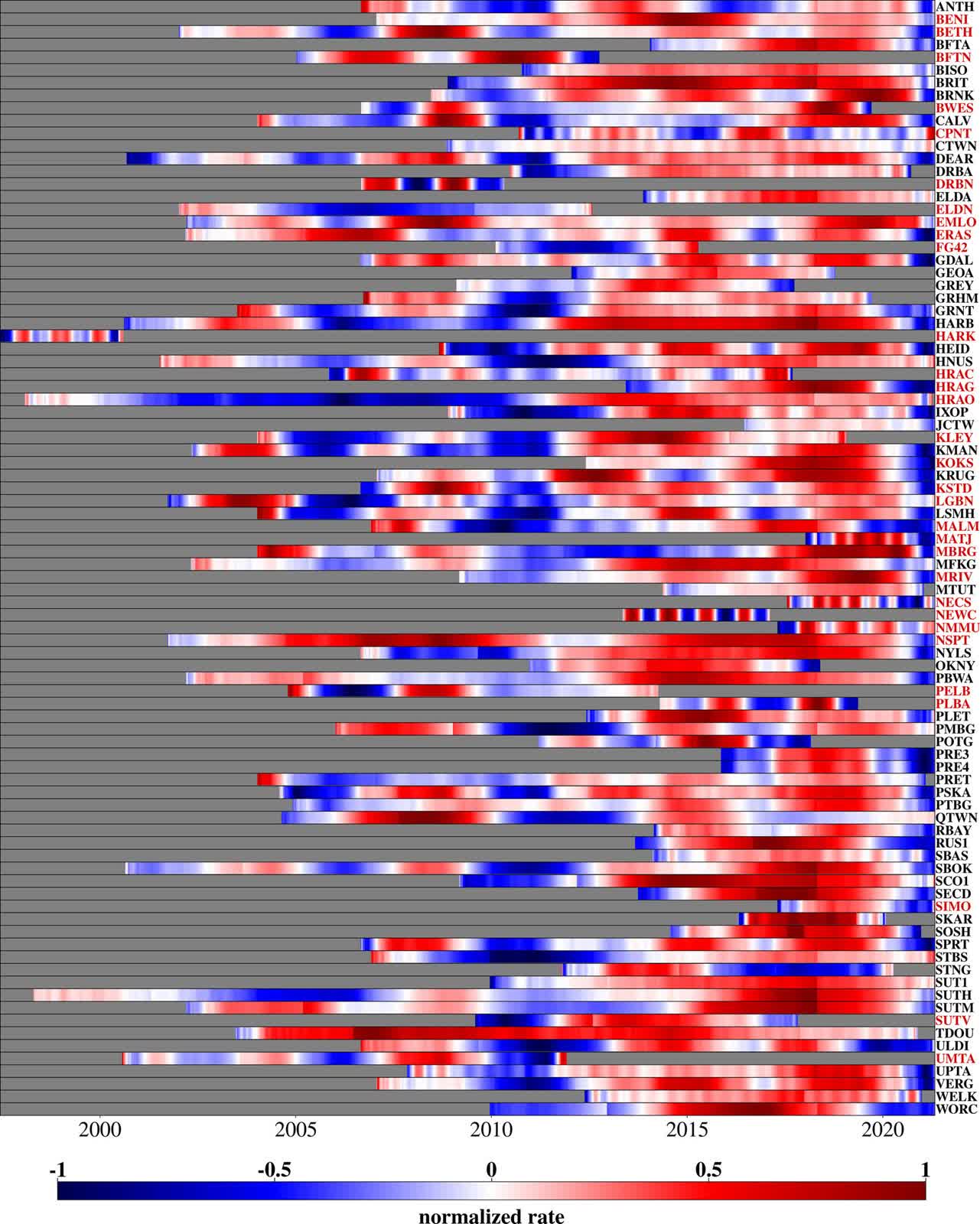
The change in height of the different GPS stations, with red indicating rising and blue indicating sinking. The rise was particularly pronounced during the drought from 2015 to 2019.
While revolutionary for mapping large-scale water mass changes, the University of Bonn notes that the GRACE satellites offered only coarse regional snapshots with resolutions spanning hundreds of kilometers. Researchers turned to hydrological models that simulated water cycles at far finer scales to fill the gaps. These models confirmed what field data suggested: as reservoirs emptied, soils parched, and groundwater dwindled, the Earth's crust rebounded like a foam ball released from a clenched fist.
These models confirmed what field data suggested: as reservoirs emptied, soils parched, and groundwater dwindled, the Earth's crust rebounded – like a foam ball released from a clenched fist. This elastic response isn't merely academic. Nearly half of South Africa's freshwater reserves lie underground, tapped relentlessly for agriculture, industry, and drinking water.
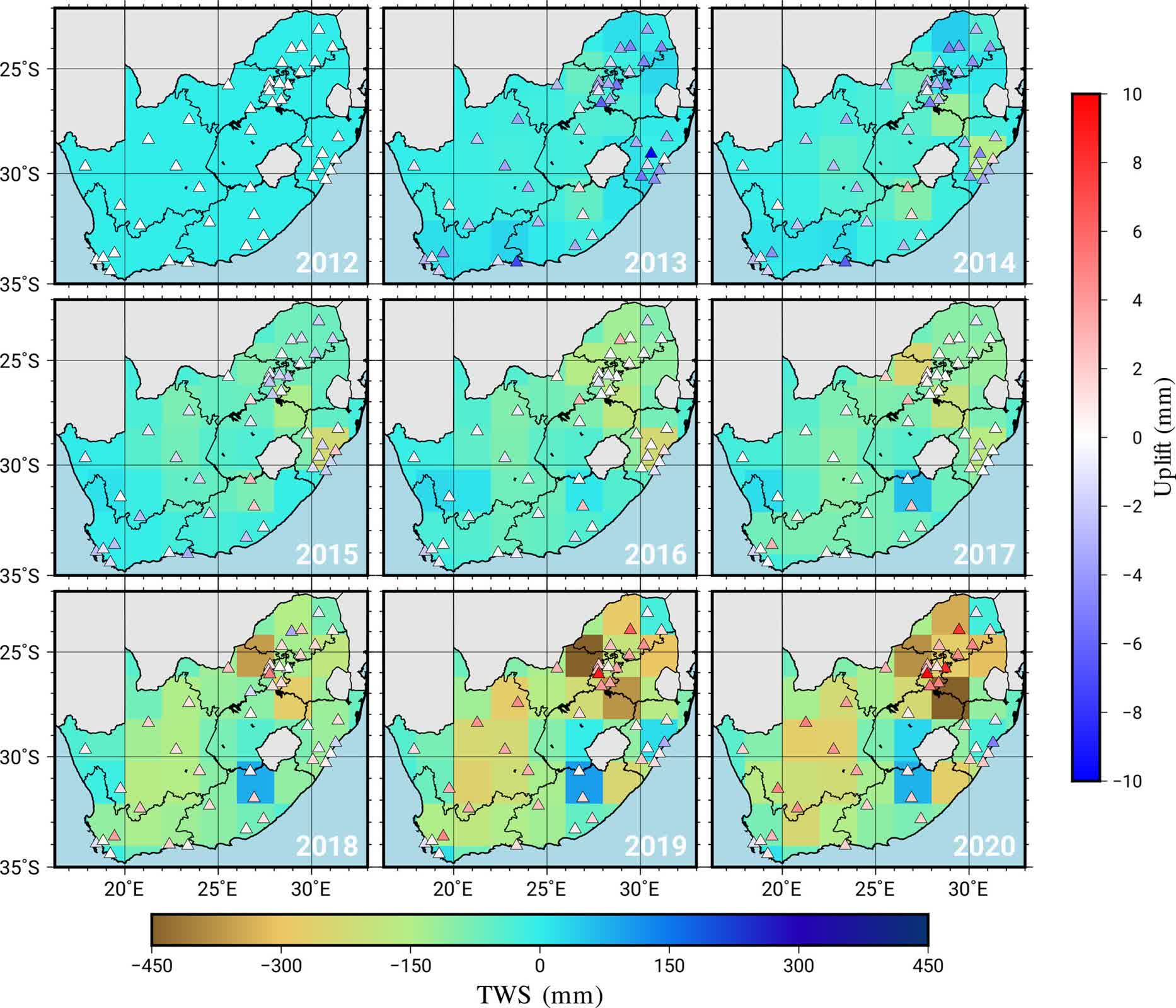
Water losses and gains in South Africa between 2012 and 2020. The browner the region, the higher the water loss. The triangles represent GPS stations, and a red triangle means that this station has risen in height since 2012.
The 2015-2019 drought, which brought Cape Town to the brink of "Day Zero" – when taps would have run dry – exposed the fragility of these reserves. Now, the same GNSS stations that detected the uplift could become early-warning systems, as scientists can estimate groundwater loss by measuring how the land lifts. This data could help guide decisions on when to ration water before crises strike.
The implications extend beyond national borders. As climate change disrupts rainfall patterns worldwide, this method provides a low-cost tool for monitoring groundwater in regions from California to the Indus Basin. South Africa's experience could serve as a prototype for water-stressed areas across the globe.


 English (US) ·